
The Blackfoot Valley's News Source Since 1980
The Blackfoot Valley's News Source Since 1980
Lewis and Clark wrote of the Gates of the Mountains on the Missouri River, "... this evening we entered much the most remarkable clifts that we have yet seen."
Almost immediately upon departing the Three Forks area, the newly formed Missouri is neatly tucked into a mini-gorge. Then, only 16 miles from its inception, the Toston Reservoir and Dam decelerate its flow. After traversing the "Little Gates of the Mountains," so noted on Clark's map of July 25, 1805, as "2d range of mts - little gate," near the small village of Toston, the river will soon ply the last of the big southwest valleys. Officially established when the post office opened in 1882 and named after a local rancher, Tosten bills itself as "the first town on the Missouri."
Wandering north between the Bridger and Belt mountains on its eastern flank and the Elkhorn Mountains to the west, it finds its way to the Prickly Pear Valley and the Helena area.
Early on the morning of July 24, 1805, Lewis and his men "passed a remarkable bluff of a crimson coloured earth on Stard. intermixed with Stratas of black and brick red slate." These are now called the Crimson Bluffs and are located about a mile southwest of Townsend.
Somewhere along today's Canyon Ferry Lake in the mid-to-late-1800s, John Oakes ran a ferry to access the gulches, including Confederate, in the Big Belt Mountains. The Missouri's channel he crossed was in a canyon, hence the name Canyon Ferry. A 30-foot high dam was built in 1889, and construction on the replacement, present-day Canyon Ferry Dam, began in May 1948 and was completed in June 1954. The resulting 26-mile long Canyon Ferry Lake has 76 miles of shoreline.
By this time, the river has covered 42 miles of gentle meanders. It then enters an almost 70-mile long stretch of the series of Canyon Ferry, Hauser and Holter lakes and dams. All three were built to harness the Missouri and create electric power, with recreation as a secondary consideration. In that section, it will have lost only a little over 500 feet of elevation since Three Forks.
Hauser Dam was completed in 1911 by Sam Hauser to bring power to the mines in Butte and the smelter in Anaconda. Holter Dam came on line in 1918 and was named for Anton Holter. Both men were Helena-area mining tycoons and businessmen. Hauser also was a partner with Granville Stuart in the famous DHL Ranch north of Lewistown.
Between Townsend and Helena, the river crosses country that gold settled. On the east side of Canyon Ferry Lake, up in the Big Belt Mountains, was an extraordinarily rich placer-gold find. In December 1864, two Confederate soldiers struck it big here. Naming this site Confederate Gulch after their political leanings, they built four cabins to settle into for the winter. The path in the snow among the cabins formed a perfect diamond, so they christened the camp Diamond City. At one time, 5,000 people crowded in the narrow canyon, and it was said that some of the hillside prospectors garnered more than $1,000 worth of gold from a single pan of gravel. The big boom was over by 1870, and in 1880 only a couple of people remained. Today, not even the town's footings are left – washed away by hydraulic mining once townsfolk realized they had assembled their homes atop the gold.
On the afternoon of July 14, 1864, four men, nursing their bad luck in the gulches and camps of Alder Gulch and Grasshopper Creek to the southwest, and who had been following rumors of gold to the north in the Kootenai country, returned to a gulch they had prospected a bit earlier. This was to be their "last chance." Digging to bedrock in a canyon below today's Mount Ascension and Mount Helena, they hit paydirt. A camp called Last Chance (later Helena) was mapped out and, as other would-be miners and prospectors migrated to the Prickly Pear Valley, became an overnight boom.
More ore was found, and additional camps, most of which have long since disappeared, were established. Today, as the Missouri passes remnants of those livelier times, she remembers how it was.
The Eldorado Bar, once a gold placer claim, is now worked by current day prospectors looking for sapphires in the gravels just off of the Missouri River.
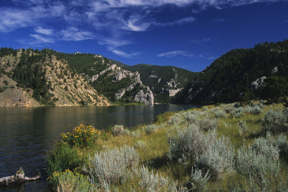
Downstream from Canyon Ferry Lake, and northwest of Helena, the Missouri's waters edge the western perimeter of the Gates of the Mountains Wilderness. Here, the river's channel narrows to knife its way through steep limestone walls. Lewis' journal notes of July 19, 1805, read in part: "... this evening we entered much the most remarkable clifts that we have yet seen. these clifts rise from the waters edge on either side perpendicularly to the hight of about 1200 feet ... the towering and projecting rocks in many places seem ready to tumble on us ... for the distance of 5 3/4 miles ... the river appears to have woarn a passage just the width of it's channel or 150 yds. it is deep from side to side nor is ther in the 1st 3 miles of this distance a spot ... on which a man could rest the soal of his foot ... from the singular appearance of this place I called it the gates of the rocky mountains."
When the river passes through the Gates, it takes on the Adels, an extension of the Big Belt Mountains. Here, held back by the last of the upriver dams, it fills Holter Lake. After the dam, the Missouri sweeps by the east side of a recreation community, named for Warren Craig who built the first cabin here in 1886. It is now relatively free to run unobstructed for 89 miles until meeting the Sun River at Great Falls.
As the Adels trail off, the Missouri bids farewell to the Northern Rocky Mountains. Near the community of Cascade, a sleepy farm and ranch town with one foot on the prairie and the other in the mountains, the mighty river makes a transition from big valleys and peaks to the open plain where it will hit full stride with space to spread and grow.


Reader Comments(0)