The Blackfoot Valley's News Source Since 1980

NWS personnel visit LVFD to talk snowpack, flooding

A presentation on last winter's lingering snowpack and the impact it's expected to have on flooding didn't reveal many surprises for members of the Lincoln Volunteer Fire Department, but confirmed that flooding should be expected to continue for the next several weeks.

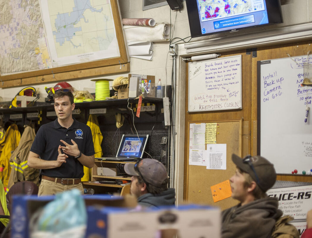
Arin Peters, the senior service hydrologist for the National Weather Service in Great Falls, meteorologist Cody Moldan and Megan Syner, the warning coordination meteorologist, visited the LVFD last Thursday, as firefighters prepare to respond to additional flooding in the area.

As of last week, Peters said the snowpack in the mountains held from 10 to 30-plus inches of water, with area snowpacks at 141 percent of average for this time of year.

Although snowpacks that were actually higher during Lincoln's last significant flood year in 2011 - in the 160 percent range - Peters agreed with Lincoln Fire Chief Zach Muse's assessment that the flooding the Lincoln area has seen so far has been primarily from the deep mid-and low- elevation snowpack. That was reflected in the National Resource Conservation Service SNOTEL site along Copper Creek, which showed that snow depths there reached into the four- foot range – nearly double what Muse has seen in the past - and lasted several weeks longer.

"A lot of the flooding that happened already this year in Montana, like up along the Hi Line, has all been from lowland snow melt," Peters said "The mountains haven't even started. That's definitely a difference this year from 2011."

Peters also noted that once the snow began to melt, the region is losing it faster than normal. In part that's because it peaked so much later. Just across the divide, the Missouri Main Stem Basin, which normally sees peak snowpack around the first week of April saw it peak two weeks later, and higher than it ever has.

"Basically, after it started melting, it's going really fast. That's why we're seeing so many swollen rivers right now," he said.

According to Peters, the National Resource Conservation Service SNOTEL site at Copper Camp north of Lincoln peaked with a snow/water equivalent of 45 inches April 20. Since then it has lost 19 inches of water, with 26 inches of snow/water equivalent showing May 15.

Nevada Ridge to the south appears to be losing both snowpack and water at a slower pace.

Between May 8 and May 15, snow depths have dropped from 47 to 39 inches, while the snow/water equivalent has decreased by just three inches, from 20.3 inches to 17.3 inches.

Muse pointed out that the SNOTEL site in Copper Camp revealed that snow packs never reached into the 120-inch range the area often sees on good snow years, but held one inch of water for every two to three inches of snow. Most years, he said it takes about five inches of snow to produce an inch of water.

A cool, rainy period forecast for last weekend proved to be a mixed blessing for Lincoln. It slowed the rate of snowmelt and flooding, but also dropped some additional snow in the higher elevations and brought about ¾ of an inch of rain.

Given the unusual conditions this year, Peters said he expects to see flooding continue for the next several weeks, with worsening conditions as higher temperatures hit the area.

"Normally we expect the peak of flooding in the mountains to come off in mid-May to June, but this year has been an anomaly so it's hard to say," he said

As Lincoln outfitter and firefighter Billy Cyr pointed out, the flooding seen so far hasn't really been affected by the Lander's Fork, which he noted has a larger drainage than the Lincoln Valley.

"Last year by June 1 Landers Fork was flooding," he said. "This year by June 1, there's still gonna be snow.

For Peters, that further indicated high elevation snow may not have begun to come off yet. "The peak around here could be three or four weeks away," he said.

Peters said they don't expect snow melt to increase flood hazards in the burn scars from last year's fires. He explained that the greatest risk from those areas happens when rain falls at a rate of half an inch or more per hour. Although the snow is melting rapidly, he said it's not melting at that high a rate.

"These thunderstorms that can form up in the mountains and sit stationary for a couple hours, those can cause some problems," he said. "We're definitely concerned about these burned areas with any kind of heavy rain."

He said they have requested weather stations for both the Park/Arrastra Creek and the Alice Creek burn areas, which,iIf approved, will help them get warnings of potentially hazardous weather out quicker than they ever have.

Syner said one of the problems is that they don't have rainfall measurements for Lincoln.

"That's a huge problem for us," she said. "We're pretty much in the dark on what is actually happening in the Lincoln area. When it comes to rain forecasting or any type of extreme weather forecasting, that data is super critical."

Synar gave Muse two rain gauges in hopes of finding area residents willing to set them up and monitor them for the Community Collaborative Rain, Hail & Snow network. "Without those measurements, we can't provide good updates." she said.

Looking ahead at the long-term outlook for the state, Peters said last winter's snow busted the drought that developed last summer, and said they have no clear indication that the state will see either above or below average precipitation. Although southwestern and extreme western Montana are expected to be drier than normal this year, he said they aren't anticipating a drought to develop this year, but admitted they weren't expecting it last year either.


Reader Comments(0)