The Blackfoot Valley's News Source Since 1980
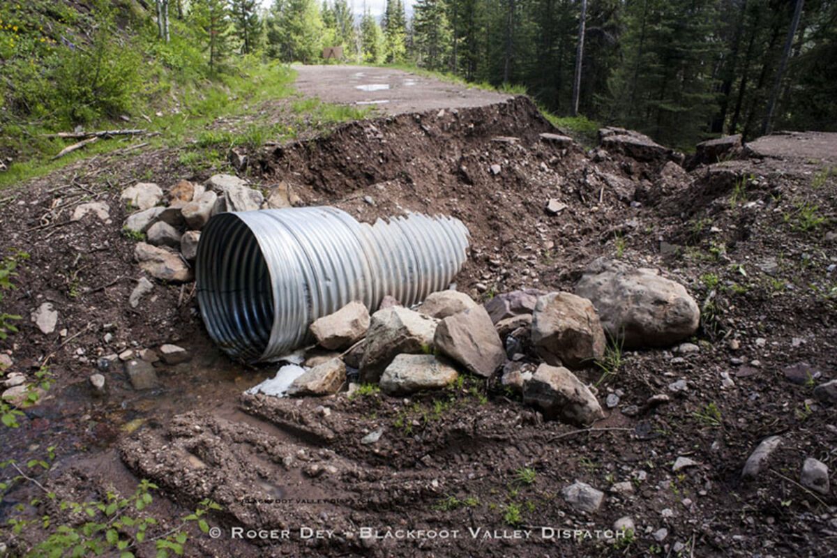
Forest roads in tough shape following long winter, wet spring

A long, hard winter and heavy spring runoff exacerbated by the conditions left behind after last year's fires, which destroyed trees that absorb water and the surface vegetation that slows it down, took a toll on roads around the Lincoln Ranger District

Forest users heading into the National Forest around Lincoln this summer may want to be on the look out for damaged roads as well as closures for repair work.

"(On) pretty near any road, I can think of some damage on it," said Lincoln Ranger District Resource Manager Josh Lattin.

For many of the roads, scarred by channels created by fast moving water from overflowing creeks and ditches, Lattin said grading and compacting should take care of the damage, but for some areas there is work left over from last year yet to be done, and in others damage from this spring was severe enough to necessitate road closures that are still in place.

Around the Park Creek Fire area north of Lincoln, Lattin said people should expect to see some construction in areas where crews will be installing culverts.

"We installed a few culverts ... but we just ran out of time because that fire ran us all the way to October," he said.

That work is expected to be limited in scope however. "We'll try to get stuff done on an individual road on weekdays, and open it up on weekends," Lattin said.

The roads on the district with closures in place may require a little more work.

A washout around a culvert on Sucker Creek Road has a section of that road closed past Keep Cool Lakes.

"That's impassable with a truck," Lattin said. "That one is priority to get repaired."

Sucker Creek Road was originally closed from forest boundary to forest boundary, but Lattin has opened most of the road.

"We had some water running across the road right after the trailhead, but that's since subsided, so the road's OK," Lattin said. "I bumped the closure back to just the culvert. That's closed at that practical point where you can't get through. You can get in both sides, it's just closed to through traffic."

To the east, Copper Creek Road has a spring that popped up in the road above Snowbank Lake. It didn't require closing the road, but Lattin called it "rowdy; a four-wheel drive kind of situation."

Beaver Creek Road west of Lincoln is in comparatively good shape.

"You can get to Huckleberry Pass now. That road is one that held," Lattin said. "Beaver Creek itself certainly had some damage, but nothing worth closing."

Stonewall Creek Road remains closed following the flooding last weekend, when runoff and debris from a rainstorm overwhelmed the Youderian irrigation ditch headgate, sending water down the roads in the area.

"We got the creek back down the drainage the same day it happened, but it had already washed all the fines off the road. We're keeping that closed until we get that repaired because it's pretty rough right now."

The Forest Service section of the road above the Parlin Park area is closed and Lewis and Clark County has closed the road outside the forest as well, with access limited only to the area's residents.

"We'll probably have to combine forces with the county so we have one crew going in to repair the whole thing, rather than two separate crews," Lattin said.

He said they may also want to work together on Lincoln Gulch Road, where water has been running down the road below the historic Lincoln Cemetery.

The issue of Lincoln Gulch Road also came up at the June 1 Government Day meeting. The public county road has been closed for four weeks by a major washout at the Glory hole, but residents voiced concerns about "lookey-loo's" who have been using the Lincoln Springs subdivision road to access the area.

Public access is technically restricted by the private subdivision road, and neither Lewis and Clark County nor the Lincoln Ranger District had closed their respective sections of Lincoln Gulch Road leading to the cemetery above the washout.

Public Works director Eric Griffin seemed open to closing the county section of the road, and Commissioner Andy Hunthausen agreed access should be limited.

"People just don't need to be up there unless you have an absolute need to be there," he said. "Until this settles down, we need to do some work to make it safe again."

Across the valley, a slide that occurred sometime during the spring blocked Sauerkraut Road, Lattin said. They discovered it a couple weeks ago, after things had melted out enough to allow them up there. He said they hoped to get machinery up there this week to start digging it out.

Flooding from the Blackfoot River closed Nevada Ogden Road at the Moose Creek Campground. Lattin said the water levels have been going up and down day to day. Although he repaired the road there once, water levels rose again and washed away his work, so they've opted to keep the road closed.

"We're kind of letting it play its hand," Lattin said. "Once we know the water has really subsided and we know it's not going to just undo everything, we're gonna go in and fix that section as well."

From a basic safety standpoint, Lattin said people need to take care on corners, since some of the roads have "greasy" spots due to washouts that may have a fair amount of clay in them. Likewise, he suggested people keep away from the edges of the road where the ground is still soft, since the shoulder might slide.

Apart for the damage to the roads, Lattin said vistors should also bear in mind the beetle and fire weakened trees, and suggested keeping a saw on hand.

"You might drive into a road and it's fine, then you spend all day hiking or whatever you're doing and you return and there might be a log in the way," he said.

Although Lattin doesn't anticipate any delays in opening roads this year, he said district personnel haven't scouted all the district roads for damage yet. Forest users also need to be aware of which roads are opened and which are closed under the Blackfoot Non-Winter Travel Plan

"That's still relatively fresh," he said. "This is the second summer of it. There are roads people are used to being open that are closed, sometimes seasonally.

Free maps detailing the roads and the dates they open are available at the district office.


Reader Comments(0)