The Blackfoot Valley's News Source Since 1980

Lincoln Out Of Date

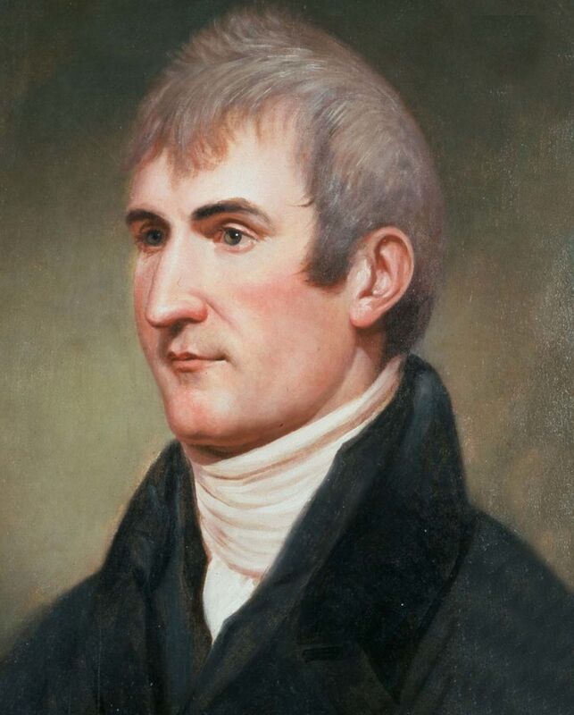
214 years ago : Journals of Lewis and Clark July 6-7 186

Capt. Meriwether Lewis made the first written record of the Blackfoot River valley in July 1806 .On July 6 he and his half of the Corps of Discovery passed through the area that is now home to the towns of Ovando and Lincoln.

July 6, 1806

Set out a little after sunrise passed the creek a little above our encampment. [probably Monture Creek]

East 14 M. to the point at which the river leaves the extensive plains and enters the mountains these plains I called (the knob plains) the prarie of the knobs from (the) a number of knobs

being irregularly scattered through it. Passed the N. fork 1 of the Cokahlarishkit River[North Fork of the Blackfoot] at 7 M. it is 45 yds. wide deep and rapid. had some difficulty in passing it. passed a large crooked pond [Kleinschmdt or Browns Lake] at 4 ms. further. great Number of the burrowing squirrls in this prarie of the speceis common to the plains of Columbia. saw some goats and deer. the hunters killed one of the latter. the trail which we take to be a re-turning war-party of the Minnetares of Fort de prarie becomes much fresher. they have a large pasel of horses. saw some Curloos, bee martains woodpeckeres plover robins, doves, ravens, hawks and a variety of sparrows common to the plains also some ducks. the North fork is terbid as is also the main branch which is about 50 yds. wide the other streams are clear. these plains continue their course S 75 E. and are wide where the river leaves them. up this valley and creek a road passes to Dearbourn's river and thence to the Missouri.-

N. 60 E 1 ½ up the river. here we halted and dine and our hunters overtook us with a deer which they had killed. river bottoms narrow and country thickly timbered. Cottonwood and pine grow intermixed in the river bottoms musquitoes extreemely troublesome. we expect to meet with the Minnetares and are therefore much on our guard both day and night. the bois rague [red osier dogwood] in blume.- saw the common small blue flag and peppergrass. the southern wood and two other speceisof shrub are common in the prarie of knobs. preserved specemines of them. [sagebrush] passed several old indian encampments of (stick) brush lodges.-

S 80 E 2m. to two nearly equal forks of the river [uncertainty about this fork] here the road forks also one leading up each branch these are the forks of which I presume the indians made mention. passed a creek on N. side 12 yds. wide shallow and clear. [probably Arrastra Creek]

N 75 E. 8m. to our encampment of this evening over a steep high balld toped hill for 2 m. thence through and to the left of a large low bottom 2 M. [probably Patterson Prairie] thence three miles through a thick wood along the hill side bottoms narrow. thence 1 m. to our encampment [Beaver Creek, in the vicinity of Good News Lane] on a large creek some little distance above it's mouth through a beatifull plain on the border of which we passed the remains of 32 old lodges. they appear to be those of the Minnetares as are all those we have seen today. killed (another) five deer and a beaver today. encamped on the creek much sign of beaver in this extensive bottom.

July 7, 1806.

Set out at 7 A. M.-

N. 75 E. 6 M. with the road through a level beatifull plain on the North side of the river much timber in the bottoms hills also timbered with pitch pine. no longleafed pine since we left the praries of the knobs. crossed a branch of the creek 8 yds. wid. on which we encamped at ¼ m. [Keep Cool Creek] also passed a creek 15 yd. wide at ¼ further. [Spring Creek] (crossed the main creek)

North 6 ms.- passed the main creek [Landers Fork] at a mile ½ and kept up it on the wright hand side through handsom plain bottoms to the foot of a ridge which we ascended the main stream boar N W & W. as far as I could see it a wright hand fork falls into this creek at 1 M. above the commencement of this course. [probably main stem of Blackfoot River]

N. 15 E. 8 m. over (a) two ridges and again striking the wrighthand fork [Alice Creek - apparently Lewis mistook Alice Creek for the same 'creek' that joined Landers Fork ] at 4 ms. then continued up it on the left hand side much appearance of beaver many dams. bottoms not wide and covered with low willow and grass. halted to dine at a large beaver dam the hunters killed 3 deer and a fawn. deer are remarkably plenty and in good order. Reubin Fields wounded a moos deer this morning near our camp. my dog much worried.

N. 10 E. 3 m. up the same creek on the east side through a handsome narrow plain.

N 45 E. 2 m. passing the dividing ridge betwen the waters of the Columbia and Missouri rivers at ¼ of a mile. [Lewis and Clark Pass] from this gap which is low and an easy ascent on the W. side the fort mountain[Square Butte] bears North Eaast, and appears to be distant about 20 Miles. the road for one and ¾ miles desends the hill and continues down a branch.

N. 20 W. 7 ms. over several hills and hollows along the foot of the mountain hights passing five small rivulets running to the wright. saw some sighn of buffaloe early this morning in the valley where we encamped last evening from which it appears that the buffaloe do sometimes penetrate these mountains a few miles. we saw no buffaloe this evening. but much old appearance of dung, tracks &c. encamped on a small run under the foot of the mountain. [Table Mountain] after we encamped Drewyer killed two beaver and shot third which bit his knee very badly and escaped.

Source: lewisandclarkjournals.unl.edu

Lincoln Out of Date: Snippets of Lincoln’s history, brought to you by the BVD and the Upper Blackfoot Valley Historical Society


Reader Comments(0)