The Blackfoot Valley's News Source Since 1980

How artificial intelligence plus local expertise can promote 'good fire' in Montana 

An emerging risk-based framework called PODs aims to improve firefighter safety, support fire-adapted communities, and get more of the right fire in the right place at the right time. Will it take hold in Montana?
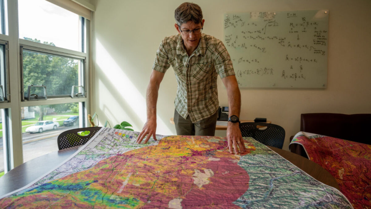
On an unassuming hillside in the Lolo National Forest outside Missoula, tall piles of dead branches and hand-thinned small trees dot the forest floor on either side of a winding dirt road. 

It's late August, and Missoula District Ranger Crystal Stonesifer and members of the district's fire management team stand outside their pickup truck and look over the mounds of woody debris, evidence of treatments being applied to the forest to slow future wildfires.

The piles indicate work in progress on what's called a shaded fuel break - a forested area where smaller fuels have been cleared to prevent a wildfire from gaining momentum. These piles will eventually be burned, leaving behind an uncrowded stand of larger trees, which is an easier place for firefighters to stop a blaze. 

Since May 2023, the Missoula Ranger District has been working to establish similar fuel breaks along 37 miles of road in the Fish, Graves, and Howard creek drainages just north of Highway 12. The goal is to improve firefighter and public safety and minimize the chance of a landscape-scale wildland fire. The use of fuel breaks as a fire management strategy is not uncommon, but there is something unique about these particular control lines: Their location was determined using a new risk-assessment tool. 

Potential Operational Delineations, also known as PODs, is the name of a collaborative risk-based framework designed to help fire managers and landowners get on the same page before fires start. Drawing from a combination of spatial analytics and local expertise, PODs aims to identify where to best suppress fire when it threatens people, property or critical infrastructure, and also where opportunities exist to leverage fire to support fire-adapted landscapes and reduce future risk.

To create PODs, stakeholders are assembled and first tasked with drawing lines on a map. The lines correspond to places where fires can often effectively be stopped, like a ridge, river, road or burn scar. Connected, POD lines create "containers" on the landscape within which stakeholders can assess risk and make plans for what to do if and when a fire starts. Depending on the risk to people, property and other values inside the POD, decisions can be made to suppress fire, conduct fuel treatments like prescribed burns or mechanical thinning, or manage a natural or human-caused ignition for ecological benefit.

Developed by the U.S. Forest Service, the PODs approach has been growing across the West since 2017. The framework is supported by a $100 million federal investment as part of the 2021 Bipartisan Infrastructure Law and is now being used by an estimated 109 national forests and regional partners. Following a series of workshops, POD lines have been drawn as of late June 2023 for all units in USFS Region 1, which includes all seven national forests in Montana. 

But full-scale embrace of the PODs framework also faces obstacles. In Montana and other western states, fire management strategies that deviate from fast and full suppression have become politically unpopular, especially as climate change fuels larger, more frequent wildfires and an increasing number of homes are built in the wildland-urban interface. At the same time, most forests across the western U.S. have evolved in conjunction with fire and depend on it for regeneration and ecosystem health. Without fire, forest composition shifts and fuels build up, which in turn increases the risk of severe wildfire, creating a dynamic known as the wildfire paradox: The more wildfire is suppressed today, the more extreme, costly and hard to contain future fires will become.

The PODs framework presents a middle path oriented toward learning to live with fire by identifying its hazards and benefits through the lens of risk. But implementing PODs also requires the consideration of a range of strategies that not all land management agencies are willing (or empowered) to pursue. In Montana, the tool is slowly gaining ground, both contributing to and relying on a broader cultural shift in fire management.

A TEST IN THE TONTO

The PODs framework was developed in 2016 by a group of researchers from the Forest Service's Rocky Mountain Research Station in Missoula. 

The idea of PODs built on previous work in California's Sierra Nevada mountains that proposed a risk map to inform fire management decisions. The original concept came from a fuels planner named Phil Bowden, who, in partnership with RMRS research forester and WRMS team member Matthew Thompson, published a 2016 paper that introduced "strategic response zones," or categories assigned to each POD based on the potential benefits or losses associated with wildfire. The idea was that strategic response zones could offer a risk-based starting point for future fire management strategies. The RMRS research group, officially known as the Wildfire Risk Management Science Team, took the concept one step further and decided to combine the risk assessment process with feedback from on-the-ground fire managers and spatial analysis tools. 

The research team developed two models - Potential Control Locations and a Suppression Difficulty Index - that helped predict where fires could be safely and effectively stopped on the landscape. 

Then, in the spring of 2017, a wildfire in Arizona's Tonto National Forest presented an opportunity to test the PODs framework on an actual fire.

Notably, another wildfire in the Tonto - called the Juniper Fire - had been managed to reduce fuels and future fire risk a year earlier. Months before the Juniper Fire ignited, fire managers had decided to conduct an experiment. Implementing a protocol similar to PODs, they pre-identified areas in one part of the forest that offered the best vegetative and topographic conditions to stop a wildfire. Then, when lightning sparked the Juniper Fire in May 2016, fire managers felt comfortable allowing it to burn to restore ecosystem health, confident that they could corral the fire along the predefined boundaries. 

At the end of the 2016 fire season, RMRS research ecologist and WRMS team member Kit O'Connor was visiting the Tonto when he learned about the outcome of the Juniper Fire. With the PODs framework recently completed, O'Connor floated the idea of working with local fire managers to develop PODs for the entire forest. They agreed.

"We said, 'What if you could [create PODs for] your entire landscape so you had a plan for every square inch and it was appropriate for the risk that was there?'" O'Connor said, recalling the initial conversation.  

A quantitative wildfire risk assessment had recently been completed for all USFS lands in Arizona and New Mexico, but that assessment was regional in scope rather than localized to individual forests. Over three days in March, WRMS researchers worked with local fire managers to build a custom risk assessment for the Tonto, essentially creating a forest-level risk profile that could be overlayed with POD lines. The resulting map defined a network of 138 spatial fire "containers" across the forest, with each container, or POD, assigned a strategic response based on the risk identified within its boundaries. In other words, if fire were to start anywhere in the forest, fire officials had a risk-based, science-informed plan ahead of time for how to manage it.

Then, in May 2017, when lightning struck a dry snag and started the Pinal Fire, managers on the Tonto were ready. Using PODs and the forest's strategic planning efforts to back up their decision-making, the district fire management officer was able to get buy-in from surrounding partners - including the mayor of the nearby community of Globe - to manage the fire simultaneously for ecological benefit and risk reduction, a strategy that ultimately created a 7,500-acre burn scar that restored pine forest and chaparral brush ecosystems and limited the risk of future fire, according to a 2019 Wildfire Magazine article. The article, which O'Connor co-wrote, attributes the success of the Pinal Fire response to understanding the risks, making a plan beforehand, and communicating that plan to partners on the landscape. 

The Pinal Fire, along with two other wildfires on the Tonto that season, became a test case for the potential impact of PODs. Researchers, including O'Connor, credit that initial effort with helping to refine the PODs framework and spur its adoption across the western U.S., where it is now in use on an estimated 109 national forests.

WHERE MACHINE LEARNING MEETS ON-THE-GROUND KNOWLEDGE

The USFS is now leading the effort to get even more fire managers engaged with PODs.

While use of the PODs framework is not mandatory anywhere, it has received strong support from the highest levels of the agency and $100 million in funding from the Bipartisan Infrastructure Law. 

If a federal, state or tribal agency wants to develop PODs, the first step is completing a workshop ahead of fire season. Local fire management staff and area partners are invited to participate and POD lines are drawn, creating a vetted network of control locations where managers are confident a fire can be stopped. Spatial analytics, like Potential Control Locations and the Suppression Difficulty Index, can then enhance on-the-ground knowledge by using landscape characteristics, transportation networks and historical fire behavior to model where conditions are safest for firefighters and control lines most likely to hold. The PCL model uses a machine-learning algorithm - a type of artificial intelligence - to estimate the probability of holding a fire in a given location based on 20 years of data, while SDI summarizes spatial data to anticipate risk to firefighter safety.

What the algorithm generates can never replace human knowledge, O'Connor said, but its success rate also speaks for itself. 

"Fire managers sometimes trust [the algorithm] better than their own judgment, which is scary because it's just a model," O'Connor said. "But at the same time, that's the track record that it has."

Ideally, prior to a PODs workshop, a risk assessment will have been created for that landscape, as was the case on the Pinal Fire. The assessment can then be overlaid with PODs to inform a plan for how fire will be managed if and when it occurs.

In addition to blending local expertise with data, fire managers and researchers have identified several other benefits of the PODs process.

Carl Seielstad, fire and fuels program manager and associate professor at the University of Montana FireCenter, started working as a firefighter for the USFS in 1990, later becoming a hotshot and then a smokejumper for 11 seasons. Seielstad currently works at UM, but also staffs and oversees the response to large, complex wildfires. 

For Seielstad, what he calls "the power of PODs" is twofold. First, the PODs framework can empower fire managers to think differently and potentially implement new strategies. Second, and perhaps more important in the short-term, PODs can be an effective tool for explaining changes in fire management to the public. For example, PODs can help the public understand fire managers' rationale for pursuing a less-than-full-suppression approach, or offer a framework for discussing the need for fire in certain areas. 

"[It] takes years to get the public on board, but the public's not resistant," Seielstad said. "They just need to think about it, and PODs lets them think about it in a way that is sensible, in my opinion." 

Another noted benefit of the PODs process is that it enables fire managers to be more proactive, rather than reactive, by offering a way to plan before fire is on the ground. Identifying control locations on a map is common practice when managers are assessing how to approach a wildfire; the difference with PODs is that the maps are available year-round, rather than created in the moment.

"If we're ever going to get over the hump in fire management of being more proactive about allowing certain fires to burn and putting other fires out, you have to think about these things and plan for them before the fire happens," Seielstad said.

Knowing where to control fire ahead of time can also reduce some of the uncertainty inherent in fire management, said Brad Pietruszka, an RMRS wildfire management specialist who is also part of the WRMS Team.

In addition, the PODs planning approach lends itself to greater buy-in from entities that fire managers have to collaborate with in fire-prone landscapes. WRMS researchers found that having conversations with neighboring federal, state, tribal and private landowners is critical, because jurisdictional boundaries are often ineffective locations to stop a wildfire. 

"It's a very low-pressure situation when nothing's on fire," O'Connor said. "If you can get people to agree to a plan before smoke is in the air, before that fire ignites, it's much easier to bring them back around and say, 'Remember, we talked about this. This is what we're doing and this is why we're doing it.'"

PODs can also inform where fuels are treated, like the shaded fuel break project on the Lolo National Forest, and offer a quick way for firefighters to get acclimated when assigned to an incident in an unfamiliar location. Once PODs are drawn for a landscape, the data is digitized and any firefighter or fire manager can view POD lines and spatial analytic tools on the publicly available Risk Management Assistance dashboard, which is hosted by the USFS Fire and Aviation Management program. 

Lastly, aligning with one of the framework's central goals, PODs can identify the right place for the right fire at the right time. 

Promoting "good" fire on the landscape is not a new idea. Historically, wildfire played a critical role in forests and grasslands across western North America. Fires resulting from lightning strikes and Indigenous burning practices cleared out accumulated fuels and also stimulated new growth, increased soil fertility and improved wildlife habitat. In addition, natural and human-caused fires left behind a fire footprint that reduced the future risk of severe wildfire.

Today, while prescribed fire and mechanical treatments help to address fuel buildup and wildfire risk, O'Connor says the pace and scale of these approaches will never catch up to the current fire deficit. 

"What we need to do is also focus on opportunities to leverage natural ignitions and grow fires out to the right places at the right time when conditions are right for that," O'Connor said, adding that recently burned areas are generally the most effective control locations for future fires.

By doing so, O'Connor argued, PODs can set the landscape up for success.

"The goal isn't necessarily to keep fire small, isn't necessarily to limit fire spread, but very much to change the type of fire itself," O'Connor said. "It becomes a fire that is critical to the system functioning, protecting our watersheds, and basically limiting the impacts of these extreme fires that could happen."

THE LAW OF THE LAND

When a wildfire occurs, fire managers face the challenge of weighing threats to personnel, public safety and property against what a 2023 study calls the "inevitability and necessity of wildland fire." Additionally, managers must grapple with a warming climate that favors more frequent and intense wildfire. 

Proponents of the PODs framework argue that it offers a pathway to better protecting firefighters, proactively developing risk-based fire management plans, and identifying where fire can be monitored and allowed to burn under low-risk conditions to improve forest health.

But there are also obstacles to using PODs to inform fire management strategies - especially strategies that diverge from full suppression.

In general, federal, state and tribal land management plans are the law of the land that dictate the suite of options available to a fire manager. Even if PODs have been drawn and risk assessments completed, a land management plan will override any strategy suggested via the PODs process that conflicts with the plan's prescribed approach.

In Montana, fire management strategies vary depending on the location.

The Confederated Salish and Kootenai Tribes' 2021 Flathead Reservation Fire Management Plan allows lightning-caused fires to be managed for ecological benefit in specific areas with high elevation timber. In other areas, where fire spread poses a greater threat to communities and valuable resources, CSKT fire managers use a combination of strategies including initial attack, prescribed burning and mechanical treatments. 

The Lolo Forest Plan, which was last updated in 1986, requires that all unplanned ignitions on the Lolo National Forest be controlled, confined or contained.

In other national forests in the state, plan language may allow for the use of natural, unplanned fires as a management tool, but Seielstad said in an email that those documents "tend to lack specificity." High-profile wildfires may involve higher levels of the USFS, but otherwise fire management decisions are typically made by a forest unit's district ranger and fire management officer based on current conditions and assessed threats to life or property. Considering the growing number of severe wildfires and the legacy of fire suppression in federal wildfire policy, cultural and political pressures can also impact those decisions.

"There's intense pressure [against] deviating from the [full suppression] status quo in fire. And I'd say that's most of Montana, honestly," Seielstad said.

Outside of the USFS, the Montana Department of Natural Resources and Conservation has a mandate to suppress all wildfires on state and private lands. The DNRC's approach to wildfire is directed by the 2020 Montana Forest Action Plan, as well as a constitutional obligation to protect commercial timber grown on state trust lands - timber that generates profits that help fund Montana schools. The Forest Action Plan permits prescribed fire and mechanical fuel treatments, but does not allow for management of wildfire based on ecological benefits.


Reader Comments(0)