The Blackfoot Valley's News Source Since 1980

Record-low snowpack widespread throughout Montana, report shows

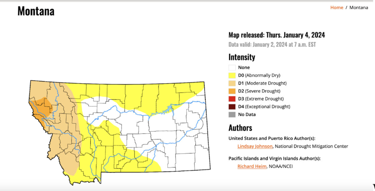
More than half of the snow-monitoring sites incorporated in the report are posting snowpack totals that are the lowest or second-lowest on record

More than half of the snowpack monitoring sites used to measure the water supply for Montana watersheds are posting record-low accumulations, according to a report out this week.

Several basins in central Montana have one-third of their normal snow-water equivalent - a measurement of water in the snow. About half of all of the basins in the report, including the Upper Missouri, Flathead, and Upper and Lower Clark Fork basins, are posting record-low totals.

Eric Larson, a water supply specialist with the Natural Resources Conservation Service, said in an interview with Montana Free Press that the snowpack was off to a good start when an October storm brought snow to most of the state, but that precipitation across much of the state "flatlined" in November and December. 

Larson said he's particularly concerned about flagging snowpack accumulations at higher elevations because they paint a grim picture for both snow-based recreation - indeed, a handful of ski areas across the state have been unable to open this winter - and the summertime stream flows that support a variety of industries ranging from agriculture and hydroelectric generation to fly-fishing. 

There are still several months of winter left to make up the deficit, Larson said, but it would take substantial storms to do so. He noted that southern Montana's snowpack was in a similar condition in January of 2017, but that significant accumulations in February - a monitoring site north of Cooke City recorded 13.5 inches of snow-water equivalent that month - brought it above normal.

"We still have some time to make some sort of recovery," Larson said. "It's not ideal to have to rely on record-setting precipitation like that, but it's a possibility."

A total of 110 of the approximately 175 monitoring sites incorporated in the report are posting totals that are the lowest or second-lowest on record, indicating how widespread the snowpack deficit is. Larson noted that most of the sites the Montana Snow Survey monitors have 40 to 60 years of records, though some sites, such as the Marias Pass site near Glacier National Park, have nearly 90 years of records.

Generally low precipitation has played a major role in the subpar snowpack conditions, though temperature has also contributed. Some of the higher-elevation SNOTEL (automated snowpack monitoring) sites in the Yellowstone area logged 50-plus degree temperatures during a three-day stretch in December, Larson said, adding that those record-warm temperatures were exacerbated by nighttime lows that didn't drop below freezing. Those conditions resulted in the already-thin snowpack melting for a short period when it should have been growing, Larson said.

"Cooler temperatures will be essential over the next couple of months to prevent any melting of the already lacking snowpack," the report notes.

The basin reporting the strongest total, Big Horn, benefited from a mid-October storm that brought "a significant amount of snow" to the Cody, Wyo., region, Larson said. As of Jan. 1, it was sitting at 75% of the median snow-water equivalent.

Larson said it's still too early to say if Montanans should anticipate a widespread return to high-severity drought. An increase in precipitation could buoy some of the considerations, such as soil-moisture measurements, that are incorporated in drought assessments, he said. 

While the U.S. Drought Monitor lists most of western Montana as "abnormally dry" or in a moderate drought, a pocket of northwestern Montana is currently listed as being in severe drought.

See original story at: https://montanafreepress.org/2024/01/05/record-low-snowpack-widespread-throughout-montana-report-shows/?mc_cid=90cdd11062&mc_eid=89795b3846


Reader Comments(0)


Rendered 04/27/2024 20:56