
The Blackfoot Valley's News Source Since 1980
The Blackfoot Valley's News Source Since 1980
Sorted by date Results 1 - 25 of 31
"Colorado is high, having more peaks within its borders than any other state. Wyoming is wide, with the breadth of the plains between the Bighorns and the Grand Tetons. California is handsome, with a splendor of success. It takes all three adjectives to describe Montana." In 1941, Donald Curloss Peattie, a naturalist of the 1920's through the 1950s, included these words in his book "The Road of a Naturalist." In 1943, Montana newsman and writer Joseph Kinsey Howard took the...

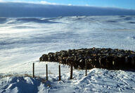
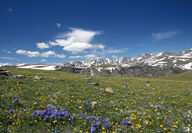
Red desert, ice caves and wild horses are symbols of a most unique piece of Montana's mountain country – the island-like Pryor Mountains of south-central Montana. From the Yellowstone River Valley and the big-little town of Billings, these Pryors appear as hills when compared to the towering Beartooths 30 miles to the west. Looks are deceiving, though. Flying just beyond their flanks, especially along the east face, reveals a steep, rugged and high landscape. Named after N...
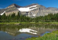
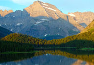
It took more than 60 years to create Glacier National Park, which is the foundation of the much larger natural system called the Crown of the Continent that we study and celebrate today. The events that led to the formation of the park and the surrounding ecosystem are regarded today as the bedrock of the conservation movement in America. What follows then is a timeline as we see it: 1849 – George Bird Grinnell born in Brooklyn, N.Y. – Sept. 20, 1849 George Bird Grinnell was...
David Alt, author and a retired professor of geology at the University of Montana, explains why gold was found in Grasshopper Creek and the surrounding gulches. "At Bannack, as in many gold mining districts, much of the production came fast and early from bonanza deposits in stream placers. Early miners working the gravels in the streambed skimmed the cream off the district, leaving the hardest work and leanest pickings for those who came later. That happens because streams...
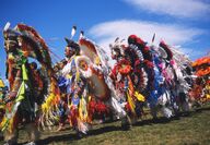
At one time, they were feared Plains warriors. Historians believe the Blackfeet, forced out of their ancestral grounds in today's upper Great Lakes region by white advancement, were one of the first Native American tribes to head West. Though there are several stories on how they received their name, the most plausible is that their moccasins were blackened from the long journey across the prairie to reach what would become Montana. The Blackfeet band now living on the Blackfe...

Call it 670 miles or perhaps more precisely 674 miles, but either way, the Yellowstone River remains the nation's longest undammed waterway. It's a great river that gathers some of the finest mountain and prairie topography on the planet as it passes peaks reaching 12,000 feet in elevation, the largest high-mountain lake on the continent, dense evergreen forests, buttes, colorful badlands, deep canyons and sweet-smelling sage and juniper covered hills. A good portion of this...
Snow had been falling almost continuously for a week, and it was very cold. The temperature had only risen to minus 18 degrees. Finally, late in the day, the snow and wind stopped, skies cleared rapidly, and as the sun set the temperature plummeted. Early the next morning, on Jan. 20, 1954, the Montana and continental 48 states' record cold temperature of minus 70 degrees was observed at a mining camp near the Continental Divide a short distance from Rogers Pass near Helena....
From the center of the state at Lewistown, it is 262 miles to Sidney and just a few miles further to the Dakota line. At night you can drive 50 miles or more and never see another vehicle. Fly over it at after dark and you rarely notice a light. This far-flung portion of Hwy 200 traverses Montana's loneliest stretch of geography. But that is this huge swath of landscapes greatest asset. For what it lacks in civilization, it makes up for in the grandeur of the prairie and the...
Sixty miles east of Missoula on Interstate 90, at milepost 166, a highway marker shows an exit for Gold Creek. In the absence of signs designating this as a significant spot in Montana's chronicles, motorists zip by at 80mph without a thought of stopping. A southerly glance shows the peaceful ranch lands of the Clark Fork River Valley gradually ascending upward toward the Flint Creek Range's peaks. And just a bit east of the road into this small community of about 200 people,...
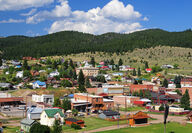
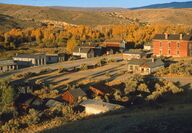
In the 1860s, as large deposits of gold, silver, copper, and other valuable minerals were discovered in Granite County, many mining settlements sprung up along creek beds and mountainsides. As a reminder of that frenzied search for prosperity, today, 24 ghost towns are left scattered throughout the county. The town of Philipsburg, founded in 1867 and named for Peter Deiesheimer, is the lone survivor and remains intact and lively. The key to this longevity is an inherently beau...
So, an Irishman and a logger walk into a Seattle bar. Imbibing spirits, they bond over their interest in knives, solve the world's problems, and by the end of the night the two new BFFs think that with no source of funding, building a massive 26-acre outdoor art gallery in the middle of woods in Montana and getting renowned international artists to participate is a swell idea. And, just like that... Blackfoot Pathways: Sculpture in the Wild was born. Well, that's my short...
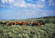
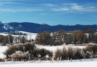
For the most part, the physical and social geography of Southwest Montana has changed little with the passage of time. Ranching and agriculture are the major lifestyles, and the Bitterroot and Gallatin valleys still draw the most folks. Water, which played a significant role in the past, is still important today. Here in this quadrant of the state is the gathering place for the rivers forming the three forks of the big Missouri. The Jefferson and Gallatin both get their start...
Fur trappers, followed quickly on the heels of Lewis and Clark into the new frontier. Searching for beaver to satisfy the latest fashion demands of Europeans, they wandered to what would become Montana Territory and particularly to the southwest sector of the state. But they were not settlers, just passers-through, and they left behind a mostly negative legacy that included degradation of the natives and a depletion of resources that saw the profits flow to only a few....
An important portion of The Corps of Discovery's journey occurred in southwest Montana. On July 19, 1805, Lewis and his men were struggling up the Missouri between present-day Upper and Lower Holter lakes. "from the singular appearance of this place I called it the gates of the rocky mountains." The next day, searching for "the three forks of the Missouri," they entered the first of southwest Montana's big valleys – Helena's Prickly Pear Valley. Arriving at the meeting of t...
Defining a province like Southwest Montana is subjective. For us, an imaginary line commences at Lolo Pass west of Missoula and moves east along Interstate 90 and the Clark Fork River to Garrison Junction. Then it follows Highway 12 over McDonald Pass to Helena. From there, our boundary extends slightly in a southeasterly direction, taking in the Big Belt Mountains before heading to Bozeman and then along the Gallatin Range crest to West Yellowstone. The south and west line of...
In September 1887, the railroad arrived at Fort Benton, signaling the end of the era of river trade, and it seemed the town would die. But a Canadian trade boom opened, resulting in the establishment of the 240-mile-long Whoop Up Trail pointing north to Fort Macleod, Alberta. Although plenty of legitimate commerce was carried out, the trail became known for the illegal whiskey transported on this dangerous and adventure-filled route. Fort Benton is one of the most fascinating...
Fort Benton rests along the mighty Missouri River. Founded in 1846, it's the oldest town in Montana. During its first century, Fort Benton would become a springboard for trade as goods would be offloaded at the navigable end of the Missouri River and transported west by wagon. Flood control and other initiatives in the 1940s rendered Sioux City the new head of navigation on the Missouri, as the Great Northern railroad would become the primary means of transportation to the...
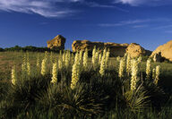
Two particular flowering plants are the toast of late spring and summer in Montana. In the mountain forests and openings of northwestern Montana, beargrass – the official flower of Glacier National Park – struts its stuff along roads and highways, as well as throughout the wilderness areas in northwest Montana. Meanwhile, the sturdy yucca stands guard over the rolling land and river breaks east of the mountains. Both plants, so similar yet so different, are symbolic of the...
When the Corps of Discovery returned to St. Louis in September 1806, fur trappers already were on their way to the new country. In North Dakota, after meeting a group of trappers heading upriver, the Corps' John Colter left the expedition and returned to the country he fondly recalled. In 1808, Colter and John Potts were trapping at the three forks when they encountered Blackfeet hunters and warriors. Potts was killed, and Colter was given a chance to escape. The Blackfeet too...
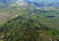
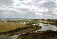
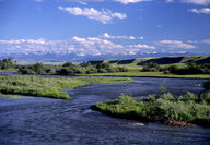
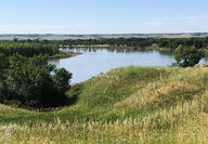
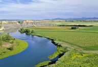
A labyrinth of channels, willow bottoms, islands and a general mix of wetlands interact to piece together the headwaters of the Missouri River. The point where the three forks – the Jefferson, Gallatin and Madison rivers – join as one, the great Missouri River begins an odyssey, heading out as having had the starring role in the creation of a state. As a route of western expansion, the Missouri River had few equals. Missouri Headwaters State Park, at the three forks, doc...
Editor's Note: This is the second part of a column celebrating 'This is Montana,' a University of Montana program delivered to an estimated 80-plus high schools and newspapers. Enjoy! Although Montana's history may be young, it certainly is deep, and much of its evidence is written on the land. Knowing that an old trail – the Mullan Wagon Road – followed the Clark Fork River, explains scars along a bench or hillside and the disappearing pieces of a cribbage that supported a b...
Editor's Note: In September 2013, University of Montana geography faculty member Rick Graetz and Kayde Kaiser, a geography graduate student, launched the "This Is Montana" program as an outreach effort that is delivered to an estimated 80-plus high schools and newspapers. Articles penned by UM faculty and others cover numerous Montana-oriented subjects, ranging from a series on the Missouri River to a discussion on the six-mill levy. Every few weeks, the stories and...

On June 16, 1805, Captain Clark of the Corps of Discovery – with an extremely ill Sacajawea accompanying him – halted below the confluence of Belt Creek and the Missouri River ("portage creek," to the Corps), setting up what would become the base camp for their month-long assault around the "great falls." As part of Meriwether Lewis's effort to cure the young mother, he used the water of a sulphur spring that is located across the Missouri from the mouth of Belt Creek and cal...
"... by every rule of nomenclature, the Missouri being the main stream and the upper Mississippi the tributary, the name of the former should have been given precedence, and the great-river should have been called Missouri from the Rocky Mountains to the Gulf of Mexico." Many people, especially Montanans, agree with this unknown author's statement. However, the Mississippi was explored first and thus designated the primary stem, leaving the Missouri to receive tributary...
When the Missouri River puts Cascade behind, it looks out toward the sunset and the distant Rocky Mountain Front, the range of mountains that gave Montana its label "Land of the Shining Mountains." On July 18, Lewis wrote, "We passed the entrance a beautifull river 80 yards wide which falls in a Lard (left side). Which in honour of Mr. Roberts Smith secretary of the navy we called Smiths River. This stream meanders through a most lovely valey to the S.E. for about 25 miles...